911 Command.
Mission-grade.
Innfini unifies 911 calls, CAD events, GIS locations, RMS records, field responders, cameras, sensors and agency workflows into one real-time command view — so dispatchers, commanders and field units see the same operational truth, and emergencies get resolved faster, with full post-incident auditability.

INC-2025-0041. Sixteen minutes. Every second accounted for.
A vehicle collision at 5th & Main, 14:32 on a Tuesday. What follows is that single incident as Innfini sees it — from the moment the call lands to the moment the record closes.
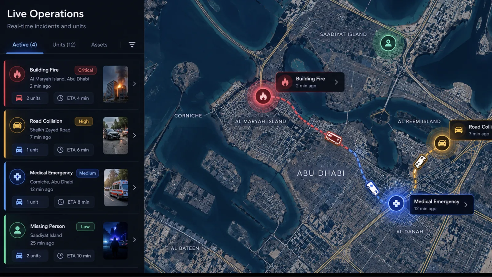
Every source on one canvas — the second it rings.
Innfini brings every emergency data source into one operational canvas. Dispatchers, commanders and field units see incidents, available units, live locations, agency status, response progress and SLA timers on the same screen.
- 911 / CAD live incident feed
- GIS map · incident + unit + asset overlay
- Unit availability & live field-team location
- Camera + sensor alerts on map
- Incident severity + SLA / response timers
- Escalation status + multi-agency coordination panel
Live dispatch, wired to the record.
Innfini bridges operational dispatch workflows with records and reporting systems, so a live incident carries its own history — prior cases, evidence, field updates and audit trail — as a single authoritative object.
- CAD incident creation · live
- RMS record lookup & case linking
- Incident timeline · field updates
- Evidence + photo + audio attachments
- Dispatch status synced both ways
- Single authoritative incident object

The next-best action — the operator approves.
The AI reads the situation, finds the nearest available units, cites the matching SOP and proposes the next action — with reasoning, confidence, SLA risk and an explicit approval gate. Nothing dispatches on its own.
- Recommendation with reasoning + citations
- Confidence + SLA risk + impact estimate
- Nearest available unit with ETA
- Required approvals + escalation path
- SOP playbook attached inline
- Approve · escalate · view cameras · open SOP

Six agencies, one operational truth.
Each agency gets role-based access to the same live incident — scoped to what they are entitled to see, federated to their own identity provider, and logged on every cross-agency action.
- Role-based access · per-agency scopes
- Shared map + scoped incident details
- Cross-agency handoff + acknowledgement
- Federated identity · SSO with each agency IdP
- Permission-aware comms (radio · SMS · console)
- Audit trail of every cross-agency action

Every action, recorded for the review.
Who created the incident, what the AI recommended, who approved it and why, which units responded and when they arrived — captured as it happened, for command, supervisor and regulator review.
- Who created the incident · time-stamped
- What AI recommended · with citations
- Who approved dispatch · identity + reason
- Which units responded · with arrival times
- Actions taken · with location + payload
- Resolution notes + evidence + final report

Faster, clearer, audit-ready.
Faster emergency response
From 911 call to crew rolling — minutes shaved at every step.
Better dispatcher awareness
Map, units, agencies, cameras and CAD on one screen.
Reduced manual coordination
AI proposes the dispatch · operator approves with one click.
Multi-agency alignment
Police · Ambulance · Fire · Traffic — one operational truth.
Post-incident auditability
Every action recorded with identity, reason and outcome.
Commander visibility
Real-time supervisor + executive command views.
Innfini moves public safety teams from fragmented emergency systems to one AI-assisted command layer for dispatch, coordination, response and audit.
See 911 Command on your operation.
A walkthrough with our solutions team — your CAD, your RMS, your responders, your approval thresholds.